21st January 2026
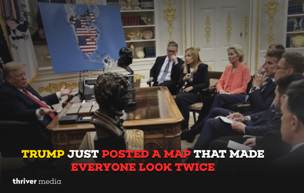
So you’re scrolling through your feed, the usual mix of news and noise, when you see it: a map of the United States that looks… different. Unfamiliar. Bigger. Shared by none other than former President Donald Trump, the image doesn’t just show the fifty states. It annexes Canada, swallows Greenland, and claims a generous portion of northern Venezuela. For a moment, you blink. Is this a policy proposal? A meme? A simple mistake? Within minutes, the internet had its answer: it was a spectacle. And spectacles, in our digital age, have a power all their own. This blog breaks down that post, the firestorm it ignited, and what this strange moment tells us about politics in the age of viral media.
Key Points First
- What Happened: Donald Trump posted a map to his social media platform that depicted Canada, Greenland, and part of Venezuela as territory of the United States.
- The Reaction: The post exploded online, spawning instant mockery, confusion, and intense media scrutiny over its intent.
- The Context: The map was part of a promotional video for a new line of customized sneakers, not an official policy document.
- Why It Matters: The incident highlights how symbolic imagery, even in a commercial context, can dominate news cycles and shape political narratives in our hyper-connected world.
What This Blog Is About
This isn’t just a story about a cartoon map. It’s a case study in modern political communication. We’ll walk through what was posted, why it went viral faster than a fact-check, and how the world reacted. You’ll see the divide between the post’s intended purpose and its public reception, and what that chasm says about the state of politics today.
What Was Actually Posted
The map appeared on Truth Social, Trump’s social media platform, as a static image within a video advertisement. The video promoted a new venture: a line of high-top sneakers selling for $399. The map itself was stylized, clearly graphic design, not cartography. It used bold colors, with the United States in a familiar red, but its borders were dramatically expanded northward to encompass all of Canada and Greenland. To the south, a chunk of Venezuela, including its coastline, was also shaded as U.S. territory.
Crucially, this was not presented as an official government map or a policy white paper on expansion. It was a backdrop a piece of visual branding in a product promo. But when you’re a former president and current candidate, there is no such thing as an apolitical image. The context was commercial, but the audience read it as profoundly political.
Public and Media Reaction: The Internet Is Not a Geography Bee
The reaction was immediate and merciless. Social media did what it does best: it memeified the moment.
On X (formerly Twitter), users quickly dubbed it the “Trump Empire Map” and photoshopped it onto everything from historical conquests to fantasy movie posters. Canadians offered humorous resignations from their newly acquired statehood. Geographers, both professional and amateur, facepalmed in unison.
The mainstream media pounced, with headlines oscillating between bemusement and analysis. Outlets like Reuters and the AP ran straight news pieces detailing the post and the reaction, while opinion columns debated whether it was a deliberate provocation, a clumsy metaphor for economic dominance, or simply an unvetted image chosen for its bold, “patriotic” look. Political commentators framed it as a piece of “performance politics,” designed to stoke conversation and reinforce a narrative of strong, uncompromising nationalism among his base.
Map Claim vs. Reality vs. Reaction
When the map post surfaced, it wasn’t just the visuals that caught attention it was the implications people read into it. Below is a clear breakdown of what the post suggested, the real-world facts, and how audiences responded.
| Aspect | What the Post Suggested | Reality Check | Public Reaction |
| Canada | Shown as fully incorporated into U.S. territory. | Canada is a sovereign nation, a NATO ally, and the United States’ largest trading partner. | Canadians responded with widespread jokes and mockery, while commentators raised questions about diplomatic tone. |
| Greenland | Depicted as a U.S. possession. | Greenland is an autonomous territory under the Kingdom of Denmark. Trump previously expressed interest in buying it in 2019. | Revived the viral “Trump wants to buy Greenland” meme, seen as a callback to that earlier episode. |
| Venezuela | A northern coastal region shown as part of the U.S. | Venezuela remains a sovereign nation, despite political crisis and tense U.S. relations. | Viewed as the most aggressive visual choice, given existing diplomatic sensitivities. |
| Intent | Appeared to signal territorial expansion. | The post was tied to a commercial product promotion, not an official policy statement. | Interpreted by many as symbolic political bravado and “strongman” imagery rather than literal intent. |
| Official Response | Implied governmental messaging. | No official policy announcement or government statement followed. | The silence from official institutions reinforced that this was a media moment, not a diplomatic event. |
The map wasn’t released through official government channels. It lived in the world of digital media where symbolism spreads faster than clarification. That gap between image and reality is exactly why the post triggered such fast, global reactions.
Domestic Impact (U.S.): Fuel for the Narrative Machine
In the United States, the map’s primary effect was on the political news cycle. For Trump’s supporters, the image likely resonated as a symbol of national strength and boldness a rejection of shrinking global influence. It was a piece of iconography that aligned with the “America First” ethos, even if not meant literally.
For his critics and the media, it served as a potent symbol of what they see as his disregard for diplomatic norms, factual accuracy, and the sovereignty of other nations. It became a one-stop talking point, a visual that could be replayed to discuss his foreign policy approach, his penchant for spectacle, and the blurring line between campaign, commerce, and governance.
The story dominated political chatter for a full news cycle, effectively crowding out other narratives. In an attention economy, that’s often the point.
Global Impact: A Confused and Concerned World Watches
Internationally, the reaction was a mix of eye-rolls and genuine concern. While allied governments in Ottawa and Copenhagen wisely avoided dignifying a shoe ad with official diplomatic comment, the coverage in their media was sharp. Canadian newspapers ran editorials questioning the health of the bilateral relationship if such imagery becomes normalized.
In broader global news coverage, from the BBC to Al Jazeera, the story was framed as a curious example of American political theater intersecting with celebrity marketing. For audiences overseas, it reinforced a perception of U.S. politics as increasingly surreal and domestically focused, even when visually claiming their backyard. It was a minor, but telling, diplomatic irritant a symbol that complicates America’s diplomatic messaging on sovereignty and international law.
Summary
Donald Trump posted a promotional video featuring a map that greatly expanded U.S. borders to include neighboring territories. While the context was commercial, the imagery was politically explosive, triggering a viral wave of mockery, analysis, and debate. The episode underscored how powerful, ambiguous symbols can instantly capture the political spotlight in the digital age.
FAQs
It was a real graphic he posted, but it was a created, stylized image for an advertisement, not an authentic or official cartographic document.
No. The governments of Canada, Denmark (overseeing Greenland), and Venezuela did not issue formal diplomatic statements in response to a product advertisement from a candidate.
The combination was perfect: a major political figure, a visually startling and historically loaded image (land expansion), an absurd commercial context ($399 sneakers), and an online culture primed for instant memeification.
Yes. From verbally expressing a desire to “buy” Greenland to using doctored imagery in attack ads, his political communication has often leveraged bold, controversial, and symbolic visuals to dominate news cycles.
The Bottom Line
This incident is a textbook example of how modern political communication works. The literal truth of an image its context, its purpose is often secondary to its symbolic power and its ability to generate reactive energy. It’s a reminder that in today’s politics, virality and visual provocation can be as influential as policy papers, and that the line between campaigning, commerce, and statesmanship is increasingly pixelated.
Conclusion
The map showing an expanded America was, on one level, just a background graphic for some sneakers. But its journey from a product promo to a global news story reveals the core mechanics of our political moment. It shows how imagery transcends intention, how social media amplifies spectacle, and how a single post can momentarily reframe complex ideas of power, sovereignty, and national identity. In the end, the story isn’t about borders on a map. It’s about the battle for attention in a fragmented world, and the surprising tools now used to win it.
Official Source Links
- Donald Trump’s Post on Truth Social: (Note: Direct linking to Truth Social is often problematic. Search for “Trump sneakers map Truth Social” on major news outlets for referenced coverage.)
- Reuters Coverage: https://www.reuters.com
- Associated Press Coverage: https://apnews.com
- BBC News Coverage: https://www.bbc.com/news
- Fact-Check Context from Snopes or Politifact: (Search “Trump map Canada Greenland” on these sites.)
Disclaimer: The news and information presented on our platform, Thriver Media, are curated from verified and authentic sources, including major news agencies and official channels.
Want more? Subscribe to Thriver Media and never miss a beat.